
Maritime Planning Associates

Highlighted Projects
Our work spans a range of complex, real-world challenges from maritime hazard modeling to public health forecasting. Each project featured here demonstrates how MPA applies advanced modeling, scientific expertise, and operational insight to support informed decision-making across defense, environmental, and infrastructure domains.
SHARC
System for Hazard Assessment of Released Chemicals
Clients: U.S. Government, Private Industry
Focus: Hazard Modeling | Scenario Analysis
Challenge: Responding to the accidental or deliberate release of hazardous materials into aquatic environments presents a complex set of challenges. Decision-makers must quickly understand how chemicals will move through the environment, how they might transform or degrade, and what communities or ecosystems may be at risk.
Solution: MPA developed SHARC to model the transport and fate of hazardous materials in aquatic and coastal environments using a particle-based framework to simulate chemical movement and accounting for processes like dissolution, volatilization, settling, and decay. SHARC supports a wide range of materials ranging from oil and industrial chemicals to pathogens.
Results: SHARC has demonstrated effectiveness across a wide range of operational and planning contexts. It has been used to simulate the transport and fate of chemical releases in ports, inland waterways, rivers, and coastal zones under both routine and emergency conditions. SHARC’s flexible framework allows rapid scenario adaptation, making it suitable for contingency planning, real-time operations, risk communication, and regulatory engagement.
Impact: SHARC provides a unique capability to agencies, contractors, and infrastructure planners who must answer tough questions under tight timelines. Its modular architecture allows it to be tailored to a wide range of chemical, physical, and geographic scenarios making it an ideal tool for both acute response and long-term hazard planning. SHARC is in active development and used by MPA across defense, environmental, and industrial applications. It continues to evolve through operational testing, scenario development, and real-world applications in support of national security and environmental resilience.
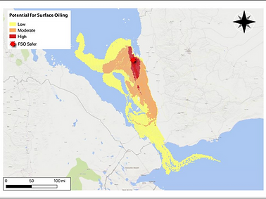
FSO Safer Spill Contingency Modeling
Client: U.S. Government
Focus: Oil Spill Forecasting | Contingency Planning | Coastal Risk Assessment
Challenge: The FSO Safer, a decaying oil tanker off the coast of Yemen, held over 1 million barrels of crude oil and presented a looming risk of catastrophic release. International agencies needed a data-driven understanding of where oil would travel under different seasonal and meteorological conditions and what environmental and infrastructure assets were at risk.
Solution: MPA used SHARC to simulate high-resolution seasonal spill scenarios in the southern Red Sea. The models incorporated currents, wind fields, temperature, and salinity to project oil movement, transformation, and fate under summer and winter conditions.
Results: The simulations showed rapid dispersion across critical areas, including more than 250 miles of coastline. Key vulnerabilities identified included desalination plants, coral reefs, fisheries, and ports. The work provided time-bound forecasts for the appearance of surface oil and shoreline impact zones.
Impact: MPA’s work equipped U.S. and partner agencies with actionable intelligence to plan for a spill with major humanitarian and ecological consequences. It informed interagency coordination, diplomatic engagement, and operational contingency planning.
Haiti Cholera Risk Forecasting
Client: U.S. Government
Focus: Disease Modeling | Disaster Response | Public Health Forecasting
Challenge: In 2021, Haiti experienced a major earthquake followed by flooding from Tropical Storm Grace. Public health officials faced heightened concern over a resurgence of cholera, a disease previously endemic in the region. They lacked clear insight into where and when outbreaks could occur given damaged infrastructure and environmental contamination.
Solution: MPA developed a spatial SIWR (Susceptible-Infected-Waterborne-Recovered) model to simulate cholera transmission driven by hydrology and population exposure. The model incorporated rainfall, elevation, water flow paths, and population density to forecast outbreak conditions across Nippes, Sud, and Grand’Anse departments.
Results: Model outputs identified elevated risk zones in Les Cayes, Miragoâne, and Jérémie within a 10–14 day window. The forecasts were used to prioritize deployment of sanitation resources, clean water interventions, and targeted health communications.
Impact: The effort demonstrated how SHARC’s underlying framework could be adapted for biological hazard forecasting, providing a scalable tool for future disease modeling in vulnerable or post-disaster regions.
